BOA 42602

Hidden Treasures

Home
Hidden Treasures
Area Attractions & Entertainment
Local Business & Services
Continuation of Business & Services
Real Estate
Free Trading Post
Straw-Bale Building and Construction
Cool Links, Games & Lake Information
Our Location
In Memory
Advertising Rates
The Boater's Buoy
BOA Wholesale Cut Flowers
For the Rock Hounds, Spelunkers and Outdoors people...

There are many exciting things to do outdoors in Clinton County and the surrounding area.  Some of those hidden treasures are only known by the locals.  Some of these hidden treasures consist of the things that I used to do as a kid while growing up in the Lake Cumberland & Dale Hollow area of south central Kentucky.
 
I've listed a few of my favorite outdoor activities and will add more at a later date.
 
If you know of a "Hidden Treasure" in the area, let me know and I'll add it to this page.

CANEY BRANCH CHURCH
caneybranch.jpg
PHOTO BY KYLE COLE
Caney Branch Cave:
Looking for adventure? Just getting there may be enough.

Less than ten miles from Albany Kentucky, is the Caney Branch Church.  Behind the church is a bluff that winds its way through the mountains to just this side of nowhere. However this bluff also hides the entrance to a cave that is locally known as the Caney Branch Cave.  Little else is known about this cave other than it runs under the graveyard, and for this reason, it has been shied away from by the locals for the past two hundred or so years.  It is rumored that someone did brave the dark underground passages and discovered an exit in a sinkhole on the edge of a field more than a mile away.  It is also said that this was not the end of the cave but just a good place to get out that required only a small amount of digging.  What secrets lie hidden beneath the earth beyond that point? 


Even if there are no noteworthy secrets, the cave is well worth seeing and exploring for its natural beauty and the adventure it so amply provides.  Your adventure begins when you attempt to get to the secluded entrance.  When you leave the backyard area of the church, you have a well-used red clay and rock path about two feet wide.  This nice little path takes you on a tour around the trees and house-size rock formations then abruptly stops at the edge of a high cliff overlooking a beautiful valley that is nestled between two tree-covered mountain peaks.  This is where your adventure really starts because you turn left and follow the ridge for a few hundred feet.  It is now that you can truly enjoy the pristine beauty that nature has so generously bestowed upon this area.  It is important that if you want to take pictures, eat, drink, or just rest that you do it now because the next five hundred yards will require your total concentration as well as a bit of good luck.  At this point you can easily identify the trail leading you around a boulder about the size of an older model VW.  However, when you get to the opposite side of that boulder the trail becomes a four-inch wide ledge with a very steep downhill grade.  You will also discover that the ledge your feet are now on is covered with loose shale that slips and slides so that navigating this section of your journey is enough adventure for most people.


OK, so you are a tough one and you want to continue.  Before you start down this part of the trail, look to your right and you will see that it’s at least one hundred feet down to the tops of the tallest trees.  Then, look to your left and notice that the cliff you are on rises about twenty feet over your head and that the jagged potential hand holds are also covered with loose shale.  The good news is that it’s only about fifteen feet down the steep trail to a relatively flat spot of at least four feet in length.  Assuming that you made it that far, you are now faced with a life-altering dilemma.  From here you can see around the rock formation that was sticking out from the cliff effectively blocking the view of the trail ahead.  You take a long look at what lay ahead, then, turn to see where you’ve already been.  You make your choice and inch your way around the rock formation.  The trail ahead is much like the one behind you except that there is no flat spot and the length is more than one hundred feet.  You also see that there are places where the four-inch width has been broken off and only one or two inches remain.  Unlike the trail behind you, there is no good news. 


In an attempt to control the length of this article, let’s assume you make it all the way down to the ledge that is in front of the cave entrance.  This ledge is four to ten feet wide, forty feet long and is supporting a number of moss-covered boulders in varying sizes.  The cliffs that guard the entrance are majestic as well as forbidding and worth exploring.  You can close your eyes and mentally visualize a family of Native American Indians making this spot their home.  It would be warm in the winter, cool in the summer, and easy to defend any time. 


You carefully negotiate the slick moss-covered rocks until you can see inside the mouth that opens facing north.  Although the sun is bright and high, the light only penetrates a few short feet into the yawning orifice and then the darkness regains control.  The first thing that grabs your attention is the human footprint in the soft dry earth of the cave floor.  You find yourself wondering if the tracks you see today were left by someone in that Native family hundreds of years ago.  When you enter the large room and look around, the chill in the air reminds you that if you go a little farther, you will be sharing space with the inhabitants of the graveyard.  That knowledge causes the natural cave chill to feel a bit colder.  


Due to the hardship you encountered getting this far, you have only one small flashlight with which to combat the darkness.  Turning it on and pointing it upward reveals that you are on the first floor of a two-story cave.  Unfortunately, because I failed to find a way up to that second story, I cannot comment on it with any knowledge.  I can however; tell you that in my opinion the person that does conquer that obstacle will have something to write about.


In the lower level you will find a small stream about three feet wide and three to six inches deep.  This stream supports small white eye-less fish, and white crayfish as well as some type of insect that resembles a spider.  The walls and floor also have an abundance of insect life forms that range from foreign to freaky.


There are many caves in the US that are virtually unexplored, but this one might hold more than one surprise in its dark depths.  The area was active during the Civil War although there were no great battles fought there.  Long before that war the Native Americans hunted, fished, and lived in and around the cliffs of Clinton County.  What stories could this cave tell if it could only talk?


John O. Braswell

Directions to the Caney Branch Cave:  From US Hwy. 127 South in downtown Albany, turn right on Hwy. 553, toward Wisdom Dock.  Continue approximately 3 miles on 553, turn right at Cross Grocery & Caney Branch Church Sign.  Park to the left of the Church.  Follow the footpath and fence row to the left of the church.  The cave is directly behind the Church.  Entrance is in a low ravine with a large overhang of rock.  Be careful!  It's slippery after a rain!

wolfcreekdam.jpg
Wolf Creek Dam-Lake Cumberland
Fossils & Geodes around the Lakes:
 
The shoreline of Dale Hollow & Lake Cumberland contain many fossils and geodes.  They are presently easy to find since both lake levels have been lowered in order to perform repair work on Wolf Creek Dam at Lake Cumberland.
 
In addition, treasure seekers who have a metal detector may find it rewarding to hunt for lost jewelry, money clips, etc. along the lowered shoreline of both lakes.  Look in locations which are swimming areas or near the docks.  You will be surprised what you can find!
 

Moderator

SEVENTY SIX FALLS
76falls.jpg
PHOTO BY PAT HORN

Seventy Six Falls:
by Jim DeForest

Most people think of Seventy-Six Falls as a family picnic area or a place to prove your courage by jumping from its heights into the waiting waters of Lake Cumberland some 35 feet below. (You hope all the way down you will miss the sunken cars below the falls.) Few realize its origin and rich history.

The creek which flows over the falls has an interesting story of its own. Indian Creek, or "Mystery Creek," as some of the old-timers call it, heads at springs on the C.E. McKinley (former Ben Aaron). Joyce Pharis, Page Coop and Eva Conner farms in the Ida community of Clinton County and flows southeast for about two miles before it reaches the lake.

The "Mystery Creek" name comes from the fact that one mile from its origin it overcomes a natural obstacle in a unique and mysterious way. A north-south running ridge seemingly blocks the creek's lakeward path. The creek flows under the ridge and surfaces on the other side, where its size is increased by eight springs. From there, the creek is turned into rapids by the steep incline about 200 yards before it falls into Lake Cumberland. Its length and average 20-foot width make it one of the largest creeks in Kentucky.

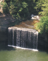
Contrary to popular belief, Seventy-Six Falls was never 76 feet high, and it did not get its name from its height. The falls were between 83 and 84 feet high until the formation of Lake Cumberland in 1950, which reduced it to its present height of about 44 feet. Most historical records note, as did James C. Ferguson in his "Early Times in Clinton County," the name was derived from the station number in the original survey, where the members of the surveying party had built a shop and lodging quarters near the top of the precipice, which measures 83 feet in length."

Seventy-Six was settled by John W. Semple in 1806. Semple recognized the commercial possibilities of its central location and the water power provided by Big Indian Creek. He began by erecting a grist mill; soon he added a general store. Semple dreamed of a thriving community around his mill.

On July 14, 1817, the Cumberland County Court vested part of his lands in the hands of trustees who laid off the town of Seventy-Six in 116 lots with lot 105 being the falls itself. Few lots were ever sold except for lots 104, 67, 68, 96, 97, and 98, bought by William Spearman on April 2, 1859 for $1,002 due 12 months after date.

Although few lots were sold at the time, Semple still believed in the potential growth of Seventy-Six. In his will of 1824, he willed to his wife, Lucy, 15 of the lots and 1/9 of the big falls.

According to Ferguson, "The mill drew trade from all over the north and center of the county; it ground both flour and meal." Nearby, was a small "warming house" which had a puncheon bench in front of a fireplace, where the men sat and parched corn on cold winter days while they waited for their turn to get their corn and wheat ground.

Beside the mill at Seventy-Six was a sawmill, a blacksmith shop, a cabinet shop, and a carding factory for wool and cotton. At the cabinet shop, all the caskets for the surrounding county were made; no charges were made for the labor, and sometimes people furnished their own lumber for the caskets. This tradition went on for about 100 years.

On April 27, 1830, a post office was established with James M. Goodson as postmaster. Through his political influence, the town's name was changed to Goodson. The citizens resented the change and on May 17, 1834, the name was changed back to Seventy-Six produced several noteworthy residents. The sons of John W. Semple , Robert and James, moved on to successful political careers. In 1845, Robert went to California, where he became president of the Constitutional Convention, while James served as U.S. Senator from Illinois from 1843 to 1845.

However, its favorite son has to be the late Senator Ed F. Warinner, whose ancestors were among the first settlers of Seventy-Six. Born there in 1909, he served the 16th district four terms in the State Senate. In 1954, he sponsored the Minimum Foundation Act (School support) and lowering of the voting age to 18. In 1958 he promoted the veterans' bonus legislation, public assistance program and the bookmobile system. The park we enjoy so much today was developed by Senator Warinner. A marker at the park honoring him (after his death in 1959) was dedicated by Gov. A.B. "Happy" Chandler on Sunday, July 31, 1970.

Today there is very little left of the town of Seventy-Six. The last remaining building, the Semple Mill, burned in 1943. The devastating tornado of 1974 destroyed many of the old trees that served as markers, and most of the park itself. Since then the park has been rebuilt and waits for you to stop and enjoy a brief visit with the past. Perhaps, if you listen closely, you can hear the noise of John Semple's mill as it grinds the wheat into flour.

Advertise your local Business or Service on the BOA 42602 Website.  Visit our Business & Service page by clicking Here.

Back to Top

BOA, PO Box 956, Albany, Ky., USA 42602
(606) 387-6621

Click here to contact BOA and request more detailed information about advertising your business or service on this site.